|
 |
 |
|
STORM PREDATOR 3 - LIVE RADAR IMAGERY SOFTWARE FOR CONTINENTAL US ONLY!
CD-ROM Version includes the complete set of additional skins and buttons, 300+ customizable topographic basemaps in higher quality than the download version, layer images, Severe Weather ScreenSaver, Auto FTP utility to upload radar images to website, and MORE!
StormPredator is packed with features to make monitoring, tracking, and alerting for severe weather easy and intuitive. You'll find that SP V3.0 can be used as your primary Internet weather information source as it contains everything you need, from radar and satellite imagery, to forecasts and severe weather bulletins.
You can have SP V3.0 send weather alerts and pictures to your email, pager, Palm Pilot, and Picture Cell Phone. Design your own skins and buttons! Support for mobile operation with portable Global Positioning Systems.
Best of all, the radar images and forecasts are always - There is no subscription service required to continue to use the program or the data. A one-time purchase of the software will enable you to own your own personal severe weather alerting center!
New features in Version 3.5 released 4/14/10
GPS Support - the program supports any GPS unit that connects to a PC via USB or serial port, and conforms to NMEA data standards (that includes virtually all modern GPS units).
The program displays a user-selectable icon marker at the GPS unit's reported location.
Changes to existing features:
The text of mobile device/pager alert messages is customizable, just as the email messages are.
The user may edit the standard message template ("pager_template.txt") to customize the alert message.
Bug Fixes:
If the beam was set to one-revolution mode, it would revolve continuously when triggered if the program is in full-screen mode.
The Save History feature could crash under some conditions.
Full Screen mode: exiting that mode could cause the desktop background to remain as the radar image.
Full Screen mode: Vista and Windows 7 platforms would lose the input focus in full screen mode (no response to keyboard or mouse until it is clicked on the display).
New Features in Version 3.4 released 10/26/09:
-- Now fully supports Windows 7, with major improvements for Vista support also. SP now installs and works well on either operating system
-- Support for Animated GIF files has been added to the Automatic Web Publishing feature
-- The installer preserves configuration settings.
The installer attempts to read any existing configuration file and preserve the settings.
In most cases the user no longer needs to enter the serial number, user name, and email during the installation.
Settings made in the program that have been saved in the configuration file are merged with the updated configuration file.
In addition, the installer correctly sets user permissions on the data storage folders.
-- The text of email alerts is customizable.
The email body text is free-form and may consist of up to 65536 (64 Kb) characters.
When the user presses the Change button in the Email Options dialog, the program begins editing a template file.
That template (named <program_data_storage_folder>\data\database\email_ template.txt) may optionally contain any of the following tags that will be replaced with values from the program when email is sent:
$TIME -- the current time
$DATE -- the current date
$ID -- the radar site METAR identifier
$CITY -- the radar site primary city
$STATE -- the radar site state abbreviation
$VCP -- the current Volume Coverage Pattern (VCP) that the site is operating in
$THRESH -- the precipitation threshold setting in dbZ designation
$VIPTHRESH -- the threshold setting in VIP designation
$DBMAX -- the maximum detected precipitation level in dbZ designation
$VIPMAX -- the maximum detected precipitation level in VIP designation
$SENS -- the current threshold sensitivity setting
$PROD -- the currently selected radar product
$DESC -- a text description of the maximum detected precipitation level
When an alert occurs or the Test button is pressed in the Email Options dialog, the template file is read and any replacements are made, and the result is stored in <program_data_storage_folder>\data\database\email_ body.txt and that file is used as the email text.
The inclusion of images is not affected by this operation.
The text of pager/mobile device messages is not affected by this change, that text is currently not customizable.
Changes to existing features:
-- The scan zone popup alert window may be optionally disabled.
This is independent of the audio alerts and email/pager messages, which are also optional.
All of these alert indicators may be enabled/disabled in any combination.
The options are set in the Display Options dialog.
-- The user may double-click on a site entry in the Location dialog to select a site.
I have no idea why this was not included in previous releases.
-- The inclusion of the scan zone and/or markers in published imagery is optional.
In the Publisher Options dialog, the user can check boxes to include or exclude scan zones and/or markers in published images.
-- Optional delay value for animated GIF files.
The user may select a value in seconds that the animation will pause at the end of each loop.
Selecting 0 (no delay) means that the last frame of the animation will pause for the same amount of time as the rest of the frames.
The option is selected in the Publisher Options dialog.
-- In previous versions, the user was restricted to testing either email or pager/mobile device functions, one at a time.
That's been changed to allow either type or both simultaneously.
-- The mail functions have been completely revised.
Please see this post in the General Discussion area of our user support forum for more details:
http://forums.stormpredator.com/showthread.php?t=372
-- Added support for VCP 211, something that was belatedly implemented by NWS/NOAA
-- The scan zone popup dialog now displays values in dbZ designation vs. VIP levels.
The VIP designations have been obsolete for many years, but are included in many radar programs (including StormPredator).
This display had been using VIP levels exclusively, contrary to the more popular dbZ values.
-- Added support for HTML email templates as well as text templates.
This allows users to send "pretty" messages that include backgrounds, logos, custom fonts and colors, etc.
Details for enabling and sending HTML mail can be found in here:
http://forums.stormpredator.com/showthread.php?p=1426#post1426
-- New palettes added.
New palettes are available for mixed precipitation, winter storm conditions, and an interesting cloud cover simulation.
Bug Fixes:
-- Numerous internal memory allocation and structure robustness fixes.
-- The Replay History feature would display the VCR-type control incorrectly.
-- The installer would fail to set permissions correctly on the program's data storage folder.
|
|
|
 |
|
 |
|
|
|
 |
|
 |
|
ALL Features
SP3 FEATURES AT A GLANCE:
 |
 Live GPS tracking support built in - plots on the map, supports many GPS units Live GPS tracking support built in - plots on the map, supports many GPS units |
|
Publish your customized radar image to your web site- stills or loops of images. |
|
Realistic map topography for all NEXRAD sites is included as standard, long and short range. |
|
9 NEXRAD radar products - including Reflectivity, Precip totals, Velocity, Echo Tops, and VIL |
|
Multiple overlay layers - roads, county borders, state/national borders, rivers/lakes, city names, and weather warnings, all instantly and independently selectable. A custom layer can be added. |
|
Instantly selectable user interfaces- Traditional round radar scope or Windows rectangular style |
|
SP3 fetches all 24 loop images available on startup. No more waiting to collect additional images |
|
SP3 can now save and playback thousands of history files, allowing for tracking entire days of storm events |
|
SP3 is now GIS accurate! Plotting lat/lon position and distances are even more accurate |
|
Show weather warnings overlaid on the radar map as they are issued by the NWS |
|
The "analyze" tool has been updated to support all new radar products in SP3, making it even more useful. It now works with single stepped images in the loop to analyze older images. |
|
Looping can now play back radar loops at real-time speeds if the graphics card/CPU supports it |
|
Custom color palettes can be loaded - such as a "winter pallete" for snow/ice |
|
SP3 now has a selectable "drop shadow" feature to make the radar echoes more visible, especially when used with TV displays that use S-Video or NTSC output |
|
Send Radar Images to Cell Phones! Sends JPEG or PNG images on Scan Zone Alerts Email, and/or Picture Cellphones, Plain text based email and pager alerts are also available. |
|
New markers Place Markers on the map along with descriptive text, over 70 to choose from, even a mobile home! Plus you can create your own markers or icons for on-screen plotting |
|
FTP to Web Pages Radar Images are automatically saved to disk for using an external FTP uploader program to send SP images to your web page. FTP program is included free in the CD ROM version |
|
Image processing and image smoothing - provides a better radar presentation |
|
Full-screen mode shows radar images in static, rotating beam, or loop mode without the user interface |
|
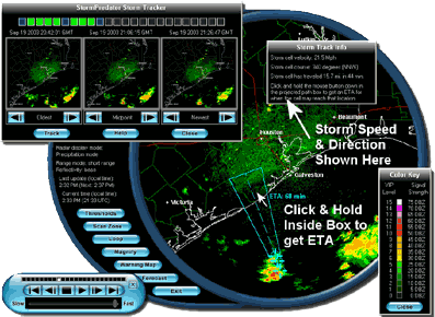
EXCLUSIVE Storm Tracker Tool plots speed, direction, distance, and ETA!
FASTER THAN NOAA WEATHER RADIO! |
|
Free radar imagery - No subscription fees! Uses public domain NWS data |
|
Latitude and Longitude position reporting with a single mouse click! |
|
Personal Weather Radar with "Always On" Live Display Mode
|
|
Personal Storm Alarm - settable for your area where you live or work - simply draw on the map
|
|
Create custom Overlays for road symbols, towns, landmarks |
|
Mini-Mode provides updated display in small format on your desktop |
|
Pop-up storm alerts with or without audio alert, customizable .WAV file
|
|
Stunning user interface with custom skins and buttons
|
|
Looping/Animation with variable speed and single step mode
|
|
Save radar loops to disk, load them again for history playback of severe weather |
|
Distance Measuring Tool- measure how far away storms are from you! - Statute or Nautical Miles |
|
Zoom Control - movable and sizable window, variable magnification
|
|
Storm Cell Analyzer- determine strength of storm cells - your own personal storm lab !
|
|
Automatic Ground Clutter blanking when in Clear Air Mode, eases interpretation - selectable on/off |
|
Background or Foreground Operation, plus compact operational modes
|
|
Full USA coverage for the entire 155 site NEXRAD Weather Radar Network, including Alaska, Guam, Hawaii, & Puerto Rico
|
|
Auto radar sweep beam with variable color, width, and speed
|
|
Auto radar image refresh and update, short and long range, plus base and composite modes
|
|
Auto radar image history download, gets image loop automatically, no waiting!
|
|
Alert Sensitivity and Threshold controls
|
|
Personal 24/7 Forecaster built in for over 60,000 USA and Worldwide locations
|
|
Interactive Weather Warnings Map, national & state levels- plus radar & satellite overlays & full text of weather bulletins
|
|
Radar Image Enhancement- choose custom colors, flash selectable echo levels for visibility
|
|
Easy and intuitive operation, Hotkeys for faster operation, plus a built in Help Reference
|
|
Works anywhere you have an internet connection - great for Storm Chasing Tours
|
|
Works with dialup modems, LAN, ISDN, Cable modems, Satellite Internet, DSL, T1...even AOL
|
|
|
|
|
|
|
|
|
| Accessories or Other Similar Products: |
|
|
|
|